Up until the early 2000s, only one satellite constellation was used to track a device’s location. The Global Positioning System (GPS) was designed by the U.S. Government for military purposes. The signal available for civilian use was deliberately altered to degrade the accuracy of the computed position. This was known as Selective Availability.
When the GPS system was opened for civilian use in May 2000, Selective Availability was turned off allowing the high accuracy experienced today. Today, most devices use Global Navigation Satellite System (GNSS) to track location with signals from multiple satellites because it provides a more accurate location fix.
Beyond Navigation: The Many Applications of GNSS Technology
More than 25 billion devices rely on GNSS technology for navigation purposes globally, including vehicles, smartphones, and drones.
In addition to navigation technology, GNSS devices are critical for many other applications, including tracking wildlife migration patterns, controlling oil rigs, and managing livestock grazing land.
The most common application of GNSS is in the field of telephony. GNSS enables companies like Apple, Google, and Samsung to provide location services for smartphones and smart watches.
What is GNSS?
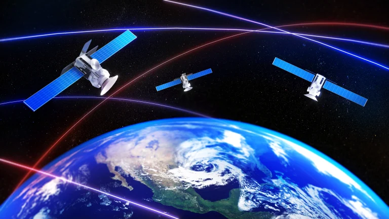
The Global Navigation Satellite System (GNSS) is comprised of the five satellite constellations from the United States (GPS), Europe (Galileo), Japan (Quasi-Zenith SS), Russia (GLONASS), and China (BeiDou). A GNSS-enabled device will pick up signals from multiple satellites within the network and calculate the device’s location most anywhere on the Earth’s surface.
GPS (United States), operated by the United States government, uses 24 satellites. The Global Positioning System (GPS) provides critical positioning capabilities to military, civil, and commercial users around the world. The United States government has invested billions of dollars in developing and deploying the GPS system, and it is a key component of the nation’s critical infrastructure. The GPS system is also a vital tool for navigation and security.
Galileo (Europe) operates independently of the United States’ GPS system and uses its own satellites as well as those from Russia. The European Union has committed to spending over €10 billion on the project, which involves building 20 satellites and ground stations in Europe.
GLONASS (Russia) was developed in the late 1970s. The first satellite in the GLONASS system was launched on October 24, 1982. Currently, there are 24 satellites in orbit around Earth that make up the GLONASS network. Many companies and industries use GLONASS alongside GPS to improve accuracy and reliability of their navigation systems, including:
- Garmin: manufacturer of sophisticated navigation tools and wearable devices
- Caterpillar: world’s leading manufacturer of construction and mining equipment
- John Deere: manufacturer of agricultural and turf equipment serving the construction and forestry industries worldwide
BeiDou (China) or BDS is owned and operated by the People’s Republic of China and provides Positioning, Navigation, and Timing (PNT) data worldwide.
QZSS (Japan) is an acronym for Quasi-Zenith Satellite System, a satellite navigation system designed to supplement GPS. QZSS was originally intended to be used only within Japan, but it has since been adopted across Asia and beyond. First launched in 2012, it consists of three satellites, and the goal is for six satellites to be launched into orbit by 2025.
The Many Advantages of GNSS for Community Corrections
GNSS works by using a network of satellites to determine the location of a device, such as an electronic monitoring device used in community corrections. The device or “receiver” is designed to pick up signals from multiple satellites.
Using a process called trilateration, the receiver measures the distance from the device to at least four of these satellites to determine its location. So, in the context of community corrections, GNSS technology offers a faster more accurate way to track the location of a person wearing an electronic monitoring device.
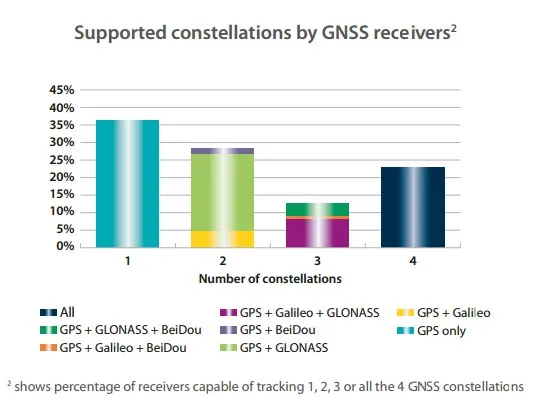
For community corrections, the use of other GNSS technology alongside GPS provides several benefits:
- Improved Location Accuracy: The use of multiple satellite signals from different GNSS systems can improve the accuracy of location data, which is critical for monitoring compliance with court orders and reducing the risk of re-offending.
- Increased Reliability: GNSS can provide redundancy in case of GPS signal blockage or interference to help ensure that location data is still being collected and transmitted.
- Greater Flexibility: The use of GNSS alongside GPS can provide more flexibility in terms of device and system compatibility and reduce signal interference, making them a valuable tool for community corrections programs, which often have limited budgets.
- Reduced Power Consumption: Some GNSS chips have built-in power management features that can automatically adjust the power consumption of the receiver based on the application’s needs.
Achieve Better Outcomes
BI Incorporated offers a complete continuum of electronic monitoring solutions that are designed to meet the unique needs of each case and provide the highest level of accuracy and reliability. From GPS-enabled to mobile devices, BI technology enables community corrections agencies to monitor individuals effectively, reduce recidivism rates, and promote successful reintegration into society. Community corrections agencies can leverage our more than 45 years of experience to achieve better outcomes for individuals under their supervision.